Kurodake ziyareti
%{resort_name} seyahatinizi planlamanıza yardımcı olacak faydalı tatil yeri bilgileri
- Sezon başlangıcı28 Nov 2026
- Sezon sonu9 May 2027
- Konaklama—
- Restoranlar | Barlar— | —
- En Yakın Havaalanı —
- En Yakın Tren İstasyonu Kamikawa
- Turizm Ofisi Web Sitesi
- Turizm Ofisi Telefonu+81 / 1658 / 53031
- Çığ bilgisi:
Kurodake Özellikleri
Kurodake arazisi şunlar içerir:
- HalfpipeNo
- Kayak parkları—
- X-Ülke—
- Kayak Kiralama—
Kurodake tesisleri nasıl bir yer?
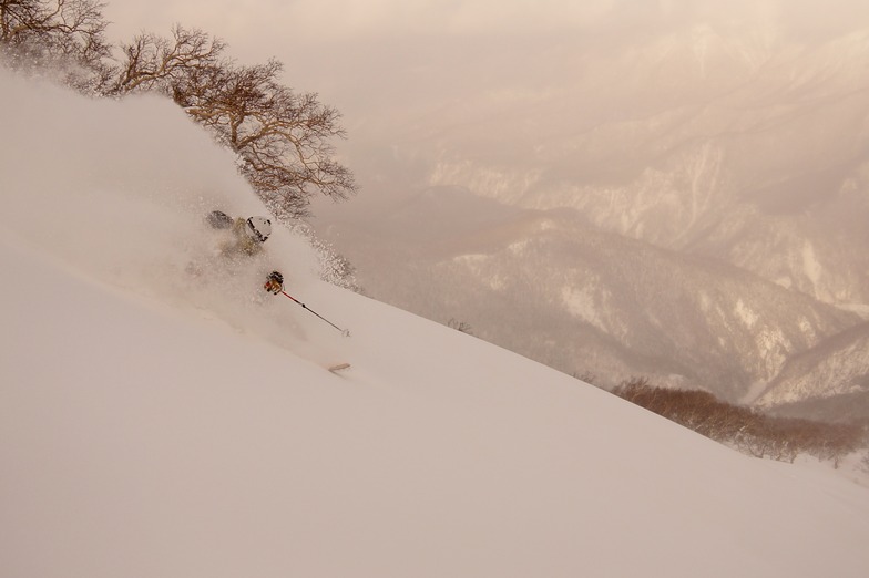
Kurodake (meaning Black Mountain) rises up above Sounkyo town in north central Hokkaido. The area forms part of the Daisetsuzan National park and is home to Hokkaido's tallest mountains. Along with skiers, the resort area also attracts a large number of sightseers who visit to see the impressive Sounkyo gorge, spectacular mountain scenery and the town's annual winter ice festival. The ski area only has two lifts; the first is the Kurodake ropeway which ascends approximately 600m above the valley floor up to 1300m. This is the steepest and most heavily forested portion of the mountain but if you look for it, there are some incredible lines to be had through this zone. There is one semi-marked run from the top of the ropeway to the valley but it is not groomed. Route finding can be difficult as there are many unmarked hazards, no avalanche control and no ski patrol. If you choose to ride the ropeway, please ride with caution and select your route carefully. Above the ropeway, there is a short, double chairlift which ascends a much lower angle slope than the ropeway up to 1560m and offers two groomed piste runs along with access to a mellow powder bowl. Given the nature of this resort, everything outside of its 2 groomed pistes should be considered backcountry terrain and treated with the appropriate respect. If you are uncomfortable accepting these risks on your own, please contact one of the local guiding companies to help you safely explore the area.
En son Kurodake fotoğrafları Tüm fotoğrafları Kurodake galeri sayfasında görüntüleyin.
 Fotoğraf kredisi: Rodney Braithwaite
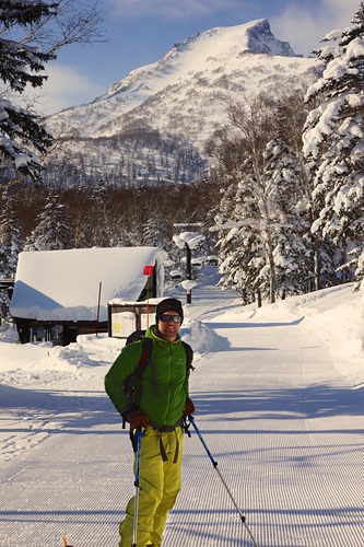 Fotoğraf kredisi: Joel O'Rourke
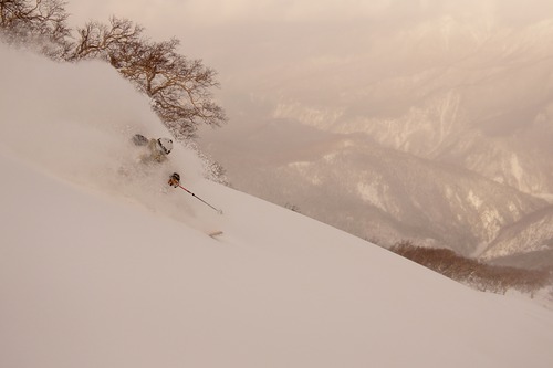 Fotoğraf kredisi: Joel O'Rourke
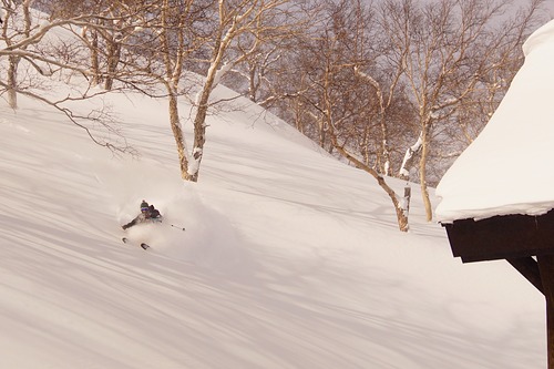 Fotoğraf kredisi: Joel O'Rourke
Kurodake Arnsberg Konum Haritasını İnceleyin
Etkileşimli Kurodake parkur ve pist haritası. Bölge kırsalını dolaşmak için pist ve parkurların yanı sıra çevredeki arazi ve dağ yapısını görüntüleyin. Kayak merkezi işaretlerine tıklayarak yakındaki kayak merkezlerini bulun ve karşılaştırın.

Bir Kurodake ziyareti için en karlı ay hangisidir?

Kurodake Ziyaretçi Yorumları
Kurodake yakınındaki tatil yerleri
Kurodake yakınındaki kayak merkezlerini keşfedin. Oradaki kayak merkezi rehberlerini görmek için aşağıya tıklayın.
 AsahidakeSon kar: 1.0 cm Wed 10 Jun
 Teleferikler: 1
 Kayak Pistleri: —10 km uzakta
- Shirogane Ski Highland Parkhill ValleySon kar: 2.0 cm Sat 09 MayTeleferikler: 1Kayak Pistleri: 433 km uzakta
- Biei ChominSon kar: 3.0 cm Mon 04 MayTeleferikler: 2Kayak Pistleri: 339 km uzakta
- PippuSon kar: 1.0 cm Sat 09 MayTeleferikler: 3Kayak Pistleri: 1042 km uzakta
- Nukabira OnsenSon kar: 3.0 cm Mon 04 MayTeleferikler: 4Kayak Pistleri: 943 km uzakta
 Nearest