
Hkakabo Razi ziyareti
%{resort_name} seyahatinizi planlamanıza yardımcı olacak faydalı tatil yeri bilgileri
- Sezon başlangıcı—
- Sezon sonu—
- Konaklama—
- Restoranlar | Barlar— | —
- En Yakın Havaalanı Rangoon
- En Yakın Tren İstasyonu —
- Turizm Ofisi Web Sitesi
- Turizm Ofisi Telefonu—
Hkakabo Razi Özellikleri
Hkakabo Razi arazisi şunlar içerir:
- Halfpipe—
- Kayak parkları—
- X-Ülke—
- Kayak Kiralama—
What's it like at Hkakabo Razi?
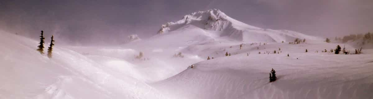
Hkakabo Razi is the highest mountain in Myanmar at 19,294 feet (5,881 metres and Myanmar was, until 1987, known as Burma.) The summit tip borders Tibet and India, also. The mountain is an extension of the Eastern Himalayas. Although low in comparison with Himalayan giants, Hkakabo Razi is perennially snow capped. Hkakabo Razi lies in the Hkakabo Razi protected area, established in 1996 which covers over 3812 square kilometres. Before 1993 this area was not accessable to foreigners. The first recorded attempt at the peak was made in 1995 by Takashai Ozaki, from Japan. He failed due to persistent bad weather. A year later he returned, and this time succeeded. Nyama Gyaltsen from Myanmar made it too. Like the main Himalayas, these mountains are heavily affected by the monsoon. Hkakabo Razi is certainly not a walk up. Huge cliffs with D+ climbing, hanging glaciers with large crevasses, and cornices, makes it a mountain not to be toyed with. The approach to the mountain is a major obstacle: there are unstable bridges, over huge gorges. For the most part, journeys are made on foot along footpaths that hug the mountainside and wind through dense jungle undergrowth. Ozaki demands four weeks walking to approach the base camp above 3000m/10000ft.
Hkakabo Razi Arnsberg Konum Haritasını İnceleyin
Etkileşimli Hkakabo Razi parkur ve pist haritası. Bölge kırsalını dolaşmak için pist ve parkurların yanı sıra çevredeki arazi ve dağ yapısını görüntüleyin. Kayak merkezi işaretlerine tıklayarak yakındaki kayak merkezlerini bulun ve karşılaştırın.

Bir Hkakabo Razi ziyareti için en karlı ay hangisidir?

Hkakabo Razi Ziyaretçi Yorumları
Canada 'den Roger yazıyor:
There was a plan to build a resort on this mountain led by former billionaire Thai Prime Minister Taksin. Of course, nothing came of it because it probably made little sense.
Hkakabo Razi ile ilgili 2 yorum daha okuyun veya kendi yorumunuzu gönderin
Hkakabo Razi yakınındaki tatil yerleri
Hkakabo Razi yakınındaki kayak merkezlerini keşfedin. Oradaki kayak merkezi rehberlerini görmek için aşağıya tıklayın.
 Auli
Auli Changchengling Ski Resort
 Nearest