Mount Fuji ziyareti
%{resort_name} seyahatinizi planlamanıza yardımcı olacak faydalı tatil yeri bilgileri
- Sezon başlangıcı—
- Sezon sonu—
- Konaklama—
- Restoranlar | Barlar— | —
- En Yakın Havaalanı Tokyo
- En Yakın Tren İstasyonu —
- Turizm Ofisi Web Sitesi
- Turizm Ofisi Telefonu—
- Çığ bilgisi:
Mount Fuji Özellikleri
Mount Fuji arazisi şunlar içerir:
- Halfpipe—
- Kayak parkları—
- X-Ülke—
- Kayak Kiralama—
What's it like at Mount Fuji?
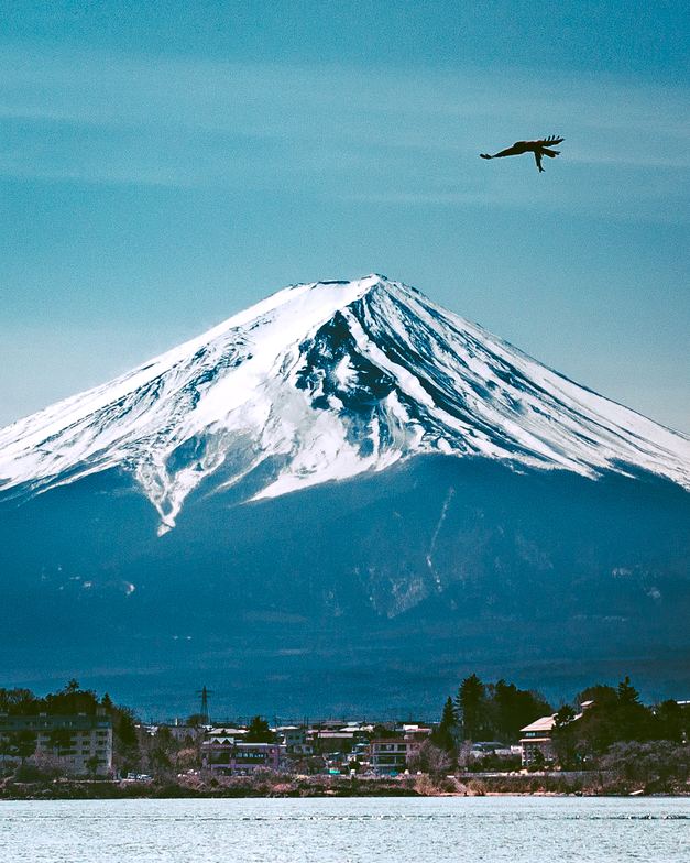
Fuji-san or Mount Fuji is the highest mountain in Japan at 12,389 feet (3,776 metres). It is an isolated volcano, located only 50 miles southwest from Tokyo, which contributes to its popularity. Thousands of climbers, tourists, and religious pilgrims ascend to the summit of Mount Fuji each year. The mountain has traditionally been sacred to the Shinto religion, and has remained sacred to Buddhists as Buddhism has become Japan's predominant religion. Three temples (plus a weather observatory) have been erected on the summit. No record exists of the first ascent of Fuji-san, but oral tradition states that a Buddhist monk first climbed the mountain in the seventh century. The mountain is now dormant, but it has erupted eighteen times in recorded history, and many more times according to geological evidence. The last eruption of Mount Fuji occurred in 1708. Perhaps, ironically for a sacred mountain, the foothills have been developed as a summer and winter sports area, and skiing on the mountain is popular in the winter. The majority of people who climb the mountain, however, do so with respect for its sanctity, and quiet meditation is common on its summit. The official climbing season for Fuji-san or Mount Fuji is July and August, but many climb in surrounding months to avoid the crowds.
En son Mount Fuji fotoğrafları Tüm fotoğrafları Mount Fuji galeri sayfasında görüntüleyin.
 Fotoğraf kredisi: Snow Forecast Admin
 Fotoğraf kredisi: Snow Forecast Admin
 Fotoğraf kredisi: gp420
Mount Fuji Arnsberg Konum Haritasını İnceleyin
Etkileşimli Mount Fuji parkur ve pist haritası. Bölge kırsalını dolaşmak için pist ve parkurların yanı sıra çevredeki arazi ve dağ yapısını görüntüleyin. Kayak merkezi işaretlerine tıklayarak yakındaki kayak merkezlerini bulun ve karşılaştırın.

Bir Mount Fuji ziyareti için en karlı ay hangisidir?

Mount Fuji Ziyaretçi Yorumları
Japan 'den Jasbir yazıyor:
Since discovering this site, I always check the weather forecast on the summit before going to Mt. Fuji.
I have been to the summit 25 times now. The forecast, on this site, is generally very accurate but the weather on Fuji is changeable and on my last trip (August 15) the forecast was for a clear night sky, mild temperatures and all good for a sunrise. Things took a turn around 01:00 around 3200m with heavy rain and very strong winds. The rain stopped around 05:00 but the winds remained moderately strong until at least 07:00 by which time I was heading back down from the summit.
Most important thing is to be prepared just in case there is a change in the weather. Some extra layers and waterproofs, even when the forecast is good, are definitely a must.
Mt. Fuji is great. I have this site bookmarked and I'm often checking the forecast a week ahead if I get that feeling I need to go to again.
Safe climbing !
Mount Fuji ile ilgili 6 yorum daha okuyun veya kendi yorumunuzu gönderin
Mount Fuji yakınındaki tatil yerleri
Mount Fuji yakınındaki kayak merkezlerini keşfedin. Oradaki kayak merkezi rehberlerini görmek için aşağıya tıklayın.
 Fujiten Snow ResortSon kar: 1.0 cm Thu 26 Mar
 Teleferikler: 4
 Kayak Pistleri: 59 km uzakta
- Snow Town YetiSon kar: 1.0 cm Mon 16 MarTeleferikler: 3Kayak Pistleri: 49 km uzakta
- Kamui MisakaSon kar: 2.0 cm Thu 12 MarTeleferikler: 5Kayak Pistleri: 524 km uzakta
- Shizuokashi Riverwell IkawaSon kar: 7.0 cm Wed 25 MarTeleferikler: 1Kayak Pistleri: 243 km uzakta
 Nearest